Table of Contents
- Territory Planning: Moving Beyond Traditional Boundaries
- From Traditional Maps to Living Networks: The Evolution of Territory Planning
- AI in Action: How Smart Territory Planning Software Boosts Delivery Efficiency
- Machine Learning: The Brain Behind Smarter Territories
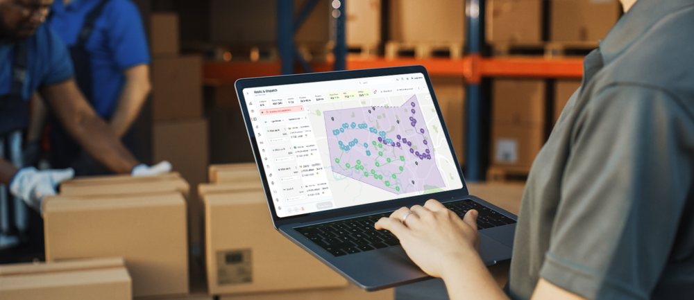
- The Human Element: Making Life Easier for Dispatchers and Drivers
- Delivering on Customer Expectations
- The FarEye Impact: Proof in Performance
- What’s Next? The Future of AI-Driven Territory Planning
- Ready to Improve Your Delivery Game?
- FAQs
Let Our Experts Optimize Your Deliveries Today
Let's talkThe world of delivery has never moved faster. The U.S. parcel shipping market is set to cross $209.2 billion as e-commerce, food and retail chains compete on speed and efficiency. Yet, for dispatchers and supply chain leaders, the real story lies in what happens behind the scenes. The challenge is getting every parcel, pallet or grocery order to the right doorstep, right on time, without wasted miles or missed opportunities.
Today, there’s growing pressure to keep up with high customer expectations and shrinking delivery windows. Industry surveys reveal that 73% of businesses cite on-time delivery as their primary competitive differentiator, while 64% say capacity utilization and cost control are their top challenges. The stakes are high, but the solution is not just about adding more vehicles or manpower.
The key lies in how well enterprises plan, adapt and execute delivery territories. This is especially true when supported by AI, advanced territory planning software, and robust delivery zone management solutions. Let’s explore why territory planning, now supercharged with machine learning and smart routing, is emerging as the core driver of capacity, speed and accuracy for modern delivery networks.
Territory Planning: Moving Beyond Traditional Boundaries
At its core, territory planning, sometimes called delivery zone management, is about dividing a wide service area into manageable zones. The intention is simple: streamline workloads, eliminate redundancy and ensure that resources are used to their full potential.
But traditional, intuition-led planning is no longer enough. In today’s dynamic environment where demand, traffic and customer needs shift every hour, enterprises require a smarter, more adaptive approach. This is where AI-driven territory planning software changes the game.
From Traditional Maps to Living Networks: The Evolution of Territory Planning
Traditional territory planning often relied on ZIP codes, manual maps or best guesses. These approaches struggled to adapt to real time spikes, seasonality and unforeseen disruptions.
Modern territory planning and delivery zone management, by contrast, are dynamic, data-driven processes. AI-based solutions territory planning platform analyzes a multitude of signals order history, traffic, driver location, customer time windows and even weather, to constantly re-balance territories and delivery loads.
The result? Balanced, compact territories that keep deliveries on schedule, maximize vehicle usage and reduce wasted miles.
Key innovations in today’s territory planning software include:
- Heatmap-based Zone Identification: AI reviews historical data and generates heatmaps to visualize high-density order areas.
- Real Time Territory Adjustments: Machine learning algorithms redraw boundaries as order volumes fluctuate, ensuring no zone is overloaded or underutilized.
- Automated Order Distribution: Orders are balanced across days and drivers, factoring in peak demand, route complexity and driver availability.
AI in Action: How Smart Territory Planning Software Boosts Delivery Efficiency
With AI-driven territory planning, delivery operations can achieve greater efficiency and reliability. These solutions turn complex logistics challenges into well-orchestrated, data-driven strategies that optimize every step from resource allocation to on-time arrivals through advanced field force automation.
1. Maximizing Capacity Utilization
AI-driven territory planning ensures every vehicle and driver is deployed to their fullest potential. By understanding historic demand patterns, current order inflows and real time traffic, AI platforms allocate resources with surgical precision.
For example, FarEye’s platform helped one pharma major increase vehicle capacity utilization by 30%. It also improved on-time deliveries by 15%, simply by redistributing workloads based on data rather than guesswork.
2. Reducing Planning Time and Complexity
Gone are the days of hours spent on Excel sheets or manual map sketches. With machine learning models, what used to take a team an entire day now happens in minutes.
FarEye’s system, for instance, can ingest up to a year of operational data and divide vast service territories into precise hexagon zones. This allows dispatchers to generate optimal territories and routes with just a few clicks.
3. Dynamic Workload Balancing
One common pitfall in delivery operations is imbalance: certain drivers are overwhelmed while others finish early. AI territory planning software continuously monitors order volume, route complexity and driver availability, redistributing work to avoid burnout and maximize productivity.
In practice, this means orders are not only delivered faster, but driver morale and retention also improve, a critical win given the industry’s driver shortage.
4. Faster, More Predictable Deliveries
By grouping deliveries into logical, traffic-aware clusters, drivers spend less time crossing the city and more time at customer doors.
FarEye’s SmartRoute engine leverages real time data to adapt to changing road and weather conditions. This delivers up to a 6% improvement in on-time, in-full (OTIF) deliveries and saves millions of kilometers in unnecessary travel.
Machine Learning: The Brain Behind Smarter Territories
So, how exactly does machine learning transform territory planning?
- Automated Analysis of Massive Datasets
AI scans order histories, route completion times, traffic records and even delivery outcomes to reveal trends invisible to the human eye. Heatmaps show where clusters of orders regularly occur; algorithms predict spikes (say, every Friday in a certain suburb) and recommend adjustments before delays occur.
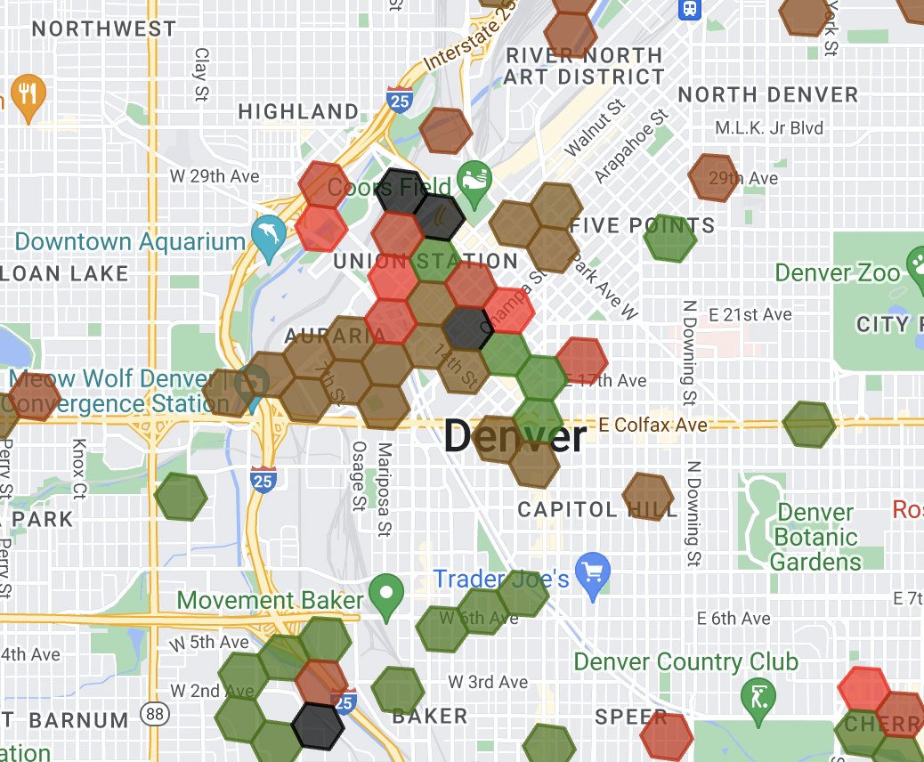
- Intelligent Zone Redesign
Instead of rigid ZIP code boundaries, modern software carves up territories into hexagonal grids, each analyzed for order density, travel times and potential bottlenecks. FarEye’s platform can merge or split these zones daily, adapting to the real flow of business rather than arbitrary lines on a map.
- Smart Resource Allocation
AI models consider every variable from driver skill sets and vehicle types to local regulations, delivery time windows and even parking availability. This means orders are not just grouped by geography, but by optimal resource match, maximizing successful first attempts and reducing returns or failed deliveries.
The Human Element: Making Life Easier for Dispatchers and Drivers
While technology drives efficiency, the true value of AI-powered territory planning comes from the tangible improvements it brings to the daily lives of dispatchers and drivers on the ground.
Dispatchers’ Perspective:
- Faster, Less Manual Work: AI-powered territory planning and field force automation tools remove the guesswork and repetition, letting dispatchers focus on exception management and strategic improvements.
- Actionable Insights: Real time dashboards and predictive analytics flag issues before they become costly, whether it’s an overloaded zone or a spike in failed deliveries.
- Seamless Integration: FarEye’s Modern tools integrate with existing IT infrastructure, eliminating silos and boosting fleet visibility.
Drivers’ Perspective:
- Fairer, More Predictable Routes: Balanced territories mean no more cross-town marathons or last minute surprises.
- Smarter Service Times: FarEye’s Smart Service Time predicts not just travel, but time-on-site, factoring in elevator waits, parking or special handling, for a more accurate schedule.
- Higher Job Satisfaction: With fewer surpris es and more manageable days, driver satisfaction and, by extension, retention improve significantly.
Delivering on Customer Expectations
At the end of the chain, every optimization in territory planning comes down to a simple outcome: better customer experience. AI ensures that:
- Delivery windows are more accurate and reliable.
- Customers can select preferred time slots thanks to predictive fleet availability.
- Real time updates and prompt issue resolution are the norm, not the exception.
In fact, FarEye platforms now harness Generative AI to provide customers with instant answers on order status, ETAs and problem reporting, building trust and convenience that drives repeat business.
The FarEye Impact: Proof in Performance
Numbers tell the story:
- Up to 18% reduction in average cost per delivery.
- Over 75 million kilometers saved via route optimization.
- More than 550,000 metric tonnes of GHG emissions are cut, making operations leaner, greener and more future-ready.
FarEye’s approach blends advanced machine learning with practical, operator-focused features like auto-merging zones daily, generating territories based on workload rather than geography and delivering end-to-end visibility from planning to fulfillment.
What’s Next? The Future of AI-Driven Territory Planning
The journey doesn’t end here. The next frontier of territory planning with AI will include:
- Hyper-local Customization
Personalizing zones in the moment, right down to city blocks or buildings.
- Mixed Fleet Planning
Plan routes for traditional, electric and self-driving vehicles all on the same platform.
- Iterative learning
With every delivery, machine learning models will learn from the delivery and self-improve, becoming smarter and more accurate every day.
Ready to Improve Your Delivery Game?
At scale, in a complex delivery network, what makes the difference between average performance and outstanding is the intelligence and flexibility of your territory planning. Indeed, by adopting AI-driven territory planning software, companies can unlock greater efficiency, improved cost control and a frictionless customer experience.
If your deliveries are feeling the pressures of rapid growth, changing demand or higher expectations. Discover how FarEye’s AI-powered territory planning software can cut delivery costs, boost capacity utilization and improve on-time performance. Request a demo today.
FAQs
- What data inputs does AI territory planning require?
AI territory planning typically uses order history, delivery addresses, real-time traffic data, driver availability and customer preferences to optimize zones and routes for maximum efficiency. - How often does the software redraw delivery zones?
Most advanced solutions, including FarEye, can automatically adjust and redraw delivery zones daily or even in real time, based on changes in demand and traffic conditions. - Can territory planning software integrate with my TMS or CRM?
Yes, leading territory planning software platforms offer seamless integration with Transport Management Systems (TMS) and Customer Relationship Management (CRM) tools through secure APIs.
Source: